Fairy Falls Circuit
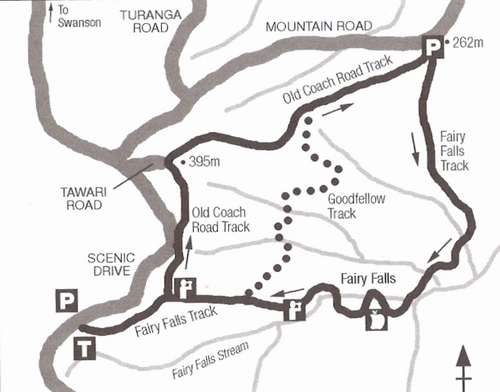
If you head out from Henderson under the railway bridge up Henderson Valley Rd and keep going, Henderson Valley Rd eventually becomes Mountain Rd and joins up with the Scenic Drive. Fairy Falls Regional Park is tucked into into the left hand corner of that junction. There are carparks available in Mountain Rd and in Scenic Drive.
NOTE: These days, my preferred route is up the Old Coach Rd track from Mountain Rd, across the Goodfellow Track, left down to Fairy Falls, and then up to Mountain Rd again. This takes in the best part of the track and the Goodfellow track is a definite bonus.
| Acknowledgements to Alison Dench and Lee-Anne Parore "WALKING THE WAITAKERE RANGES" pub New Holland Publishers (NZ) Ltd 2004. This is an excellent handbook and I thoroughly recommend it. |
| The highlight of the walk has to be the falls - some of the more spectacular to be had, coming down in a series of minifalls - but the area is rich in ferns also, and there is a large variety of native plantlife. From one rather special lookout point, you get to see Rangitoto, the Harbour Bridge, and the Sky Tower, all in one iconic photo, and framed by native trees, so a must for the visiting tourist. (Pause for coughing fit.)
Tramping conditions vary from immaculate gravel walking paths to sections with frequent muddy patches 50 -100mm deep, steep rocky goat tracks, boardwalk and steps, and floodworn ditches. There are five stream crossings, normally no more than an inch or two deep, but inclined to be slippery. Fat people and old people are advised to use sticks for stability, or better still, hiking poles.
NOTE: 25 March 2008, the goat track from the base of the falls to the first level has been replaced by tanalised wooden steps.
(The downside is that if you want to see the Falls at their most spectacular, you will have to deal with streams that are somewhat higher than this.) |
A Strenous Walk
The Montana Heritage Trail at 8km and an advertised 4 hours, is billed as "not for the faint-hearted". That's an average speed of 2 kph. But this circuit of 3.5-4 km is advertised by ARC as a 3 hour walk
(I made it 5 hours, fatman time, including time for taking pictures and admiring waterfalls.)
This is a strenuous walk, and I was grateful for my hiking poles, especially on slippery sections and stream crossings, and in particular the stiffish climb from the base of the falls, and grateful for good boots, as several areas of the older track can be inches deep in mud.
I personally believe the clockwise circuit we did is easier than the anticlockwise route starting at the Scenic Drive, judging by the obvious physical distress of a number of walkers, younger than ourselves, that we met as we cruised down the last section of the Old Coach Rd track to the Mountain Rd Carpark.
Nevertheless. if you're going to give yourself a hard time, there are few more beautiful tracks to do it on. |

memory-map graphic
For a closer look at the track, I'll deal with it in successive stages, the whole comprising a clockwise round trip from the Mountain Rd Carpark. If you're short of time and just want to catch the falls, then I recommend you start from Mountain Rd Carpark, despite the track being a little rougher in places. It's a gentle descent and a comfortable return climb.
Fairy Falls Track
Mountain Rd Carpark to Fairy Falls
page1
page 2
page 3
Fairy Falls To Fairy Falls Carpark
page 4
page 5
Old Coach Road Track
Old Coach Road Track Junction to Tawari Rd
page 6
Tawari Rd to Mountain Rd Carpark
page 7
|
|