|
|
The St James Walkway
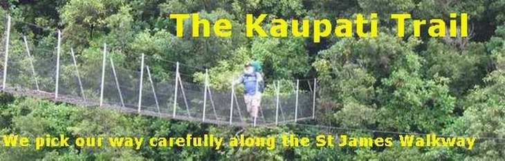
Don't get me wrong. We thoroughly enjoyed this walk. But by the fourth day the specially adapted sensor on my GPS had registered 374,528 cowpats and I think it was reading low. The St James Walkway runs 66km from the top of the Lewis Pass in a wide loop up the Maruia Valley, over the Ada Saddle and down the Ada River, then up the Henry Valley, up the Anne Valley and over the Anne Saddle, and then follows the Boyle River to the Boyle Outdoor Education Centre about 17 km from the starting point. Most people walk it in 4 or 5 days. We took 6 days. In general it is a well-behaved track as far as the elderly and stout are concerned. The first leg to the Cannibal Gorge Hut will be something of a shocker, though, if you haven't put in the hill-climbing preparation. This 7.5km leg left me fully as buggered as did the first day on the Heaphy which was 17km uphill all day. It begins with a steepish descent to the Maruia River suspension bridge, then climbs and descends the first of a long series of ridges that will ferret out all the holes in your training schedule. It ends with a stiffish climb for a hundred metres or more in which the path in front of you is about 900mm from your face, and eases off into a gentle 500m or so approach to the hut. Along the way are a couple of fairly narrow drop-offs as the track edges around bluffs and avalanche zones. From here on to the Henry River the path tracks through beech forest and valley pastures, with mountains alongside all the way, and wonderful views of the Faerie Queen at the head of the Christopher Valley. Past the Ada Homestead it becomes somewhat austere, where we hit the more or less permanent cold winds of the Henry Valley. The suspension bridge across the Henry looks much flimsier, at first glance, than anything I encountered on the Heaphy. It's not, but I reckon it's a trifle narrower. It's quite high up and the wind up the valley is close to 40 knots or more when we cross. On the other side is a 300mm wide track along the cliff, with a length of stout cable anchored to the cliff for handholds for several metres - not nearly far enough for me - and we finally descend to the valley floor. From there to the Anne hut is a stroll along the valley through matagouri and ragwort gradually climbing to reach the Anne huts across a stout wooden bridge. The next day is the longest, about 18 km in all. The track climbs easily up the Anne valley, there is a short, steeper climb through beech forest to the saddle, and then a descent to the Boyle River. From here it is possible in good weather to track all the way to the Boyle hut along the valley floor, though here and there the official track heads off up hill to avoid flood prone regions. It is a long day rather than a difficult one, with a floppy suspension bridge across the Boyle between you and the hut. The last leg starts with the same suspension bridge, and heads through beech forest around a number of ridges high above the river. The track is accommodating, and far kinder than the first leg. Another suspension bridge over the Boyle marks the turn off to the Magdalen hut, and the track winds in and out of more or less level beech forest, skirting the rather boggy flats of Glenhope station. A gentle steady climb brings you to the last suspension bridge, which is something of a cow. Its near suspension cable is about waist high across the path and it involves quite a bit of maneuvering to get a large person and a largish pack beneath it and onto the bridge, without falling into the creek below. I doubt it can be done with dignity. The last section to Boyle Village involves a few steepish climbs - the DoC team that makes steps with 500mm risers needs their collective bum kicked - and edges along the top of the bluff above the Boyle River. A final stroll through kanuka for a few hundred metres and it's off to the hot pools for a soak followed by a cold beer. (I can thoroughly recommend the roast of the day at the DB Hotel in Hanmer.) The Outdoor Education Centre is a key resource if you're doing this track. Leaving your car at the start of the track is, unfortunately, inviting a smashed windscreen. The OEC offers secure parking at $4 a day and a taxi ride to the start of the track for around $20. You can stay overnight for the same amount and a hot shower is available to casual trampers for $5.
Miranda and Carol outside the Outdoor Education Centre |
|

